
GIS in Healthcare - Public Health Location Intelligence and Mapping Solutions
Today, Public Health is under more scrutiny than ever, as Covid-19 showed, detailed analysis and strategic planning are essential to combat the health threats that may come in the future.
From assessing graphical links to illness types to attributing resources to patients in a specific area, there are many ways that GIS in public health can have a positive impact on care provision. Here are some examples of the way that GIS in healthcare can be utilized.
Use of Location Intelligence in Healthcare & Social Assistance
Explore how Geoapify's location services enhance accessibility, efficiency, and resource management in healthcare and social assistance:
Mapping Tools for Public Health Data Visualization
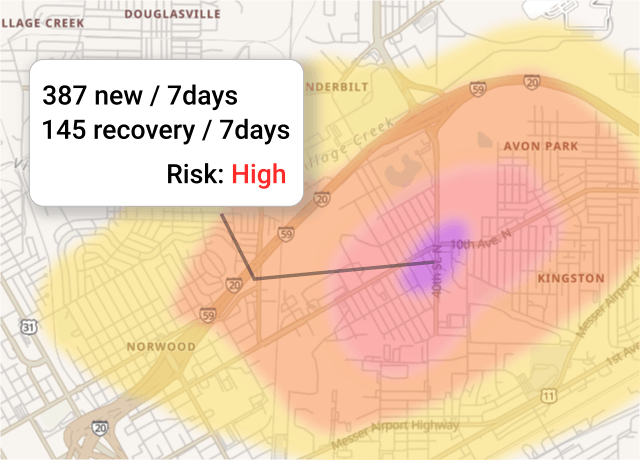
Healthcare provision is a patient-focused industry, which means it is centered around people. The location of these individuals impacts how care is provided for them, and as a result, using GIS by public health organizations can create bespoke visualizations of locations and related demographical and statistical data using map-based systems.
With Geoapify Maps, you can create beautiful data visualizations that deliver clarity for every situation. With extensive detail, analysis becomes easier, while with the Geoapify Geocoding API, you can easily search locations from within the data.
Predictions and Analysis
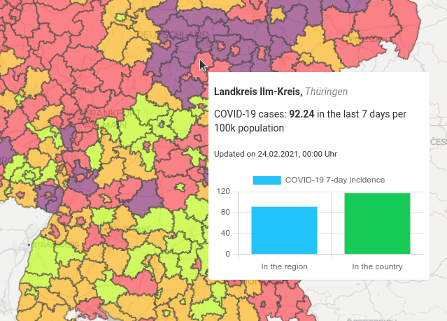
With analysis of location data, GIS in healthcare offers a wealth of new opportunities to both observe current trends and predict future ones. There are a number of analytical options available, including modeling and simulating disease spread or estimating values for uncovered areas.
With this kind of spatial analysis, public health can more accurately assess current demand and predict future needs, providing the essential short- and medium-term planning for health emergencies such as disease outbreaks.
Our Boundaries API lets you get the administrative boundaries of cities, states, and countries. You can use our Map Tiles as base maps.
Analyze Service Accessibility
Ensuring that quality care can be provided to the entire population is critical for healthcare services. Of course, that means understanding where that population is and what their needs are across those locations.
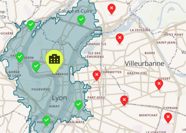
Using GIS, public health organizations can quickly highlight accessibility using Isochrones and Isodistances, pinpointing the time or distance to a facility for prospective patients in multiple locations.
The Geoapify Location Platform includes an Isolines API to calculate Isochrones and Isodistances for various transport modes, including driving, walking, bicycling, etc. This feature set enhances GIS applications in healthcare and streamlines the analysis of accessibility.

Optimize schedules for social services
Social services and healthcare often run in tandem, with doctors and social services professionals visiting several patients every day. Efficiency can save time and money, allowing the doctor or social service worker to see more patients without overloading themselves.
Public health and social service providers can take advantage of route planners that help find the optimal route and overall strategy for dealing with patients across a region. This approach prevents situations where more time is spent on the road than actually helping individuals and is an essential part of the process of delivering efficient and effective care.
The Geoapify Route Planner API offers automated optimization of schedules and routes for multiple workers and can plan effective overall strategies and detailed individual routes that account for varying individual work hours. These varying visit priorities may be needed along with any other variable required for effective planning.
What Does Location Intelligence for Healthcare Cost?
At Geoapify, we offer affordable, flexible solutions for healthcare and social service providers seeking advanced location intelligence. Our APIs are usage-based, so you only pay for what you use, allowing your organization to scale cost-effectively, whether you're a small clinic or a large social service network.
For more details, visit our Pricing Page or use our Price Calculator to estimate costs based on your specific needs. We also welcome you to contact us for personalized pricing options or any questions about our services.
Relevant Blogs and Pages
Discover how Geoapify’s powerful APIs equip healthcare and social service providers with essential tools to enhance service delivery through location intelligence. The Boundaries API offers customizable boundary data—enabling providers to define precise service areas that align with community needs. Meanwhile, the Isoline API empowers organizations to create dynamic travel-time and distance-based boundaries, ensuring optimized reach and accessibility for clients.
For organizations managing multiple locations, the Route Matrix API streamlines productivity by calculating efficient travel times and distances, supporting optimized route planning across diverse destinations.
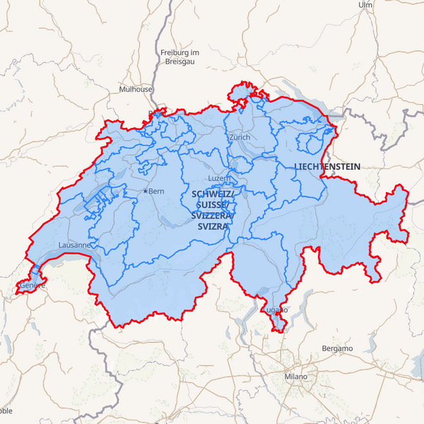
Boundaries API | Country, State and City Polygon Data | Geoapify
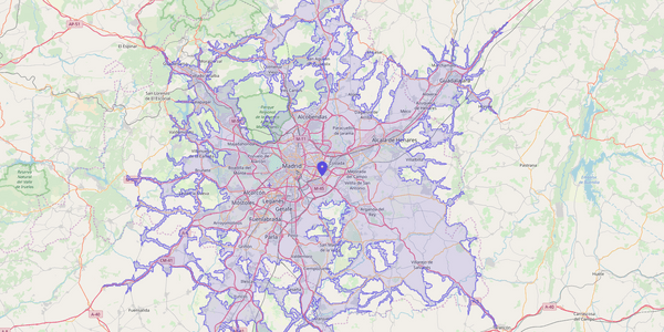
Isochrone and Isodistance API | Isoline Maps By Geoapify
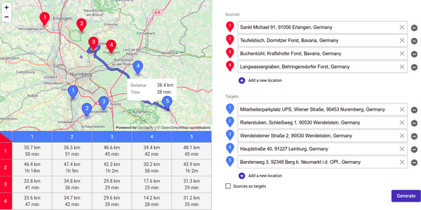
Route Matrix API
FAQ
What is healthcare location intelligence?
Healthcare location intelligence leverages GIS (Geographic Information Systems) to support decision-making in healthcare, such as identifying patient trends and optimizing access to services.
How does GIS benefit healthcare?
GIS allows healthcare providers to map health data, predict disease spread, and effectively manage resources, leading to better patient care.
What mapping software features does Geoapify offer for healthcare?
Geoapify offers data visualization, route optimization, service accessibility analysis, and predictive modeling tailored to healthcare needs.
How does GIS data enhance public health services?
GIS maps patient demographics and service access, helping healthcare organizations address demand, improve emergency response, and ensure resource availability.
How can GIS technology optimize healthcare routes and scheduling?
Geoapify’s Route Planner API helps optimize schedules for healthcare professionals, enhancing route efficiency and maximizing patient visits.
Can GIS in healthcare predict future health trends?
Yes, Geoapify’s GIS technology enables disease spread simulation and health pattern analysis for proactive public health planning.
Conclusion
Healthcare is important to us all, and for modern public health organizations, maximizing resources is essential in maintaining effective strategy and controlling costs. We have seen how through location intelligence solutions and GIS, public health can be better organized, more accurately predict disease spread and ensure resources are allocated more effectively.
When it comes to a thorough analysis, public health is always looking to control costs without compromising performance. With the ability to start with Geoapify for Free and upgrade to a paid version later, it is the perfect choice for GIS in healthcare, providing the tools and mapping solutions that social service and medical professionals need.
You can register today and begin with the Geoapify app immediately, or get in touch with us right now if you have any questions.
